Vancouver Traffic Cams Map
Get a real-time look at what’s happening on the roads with a wide network of Vancouver traffic cameras positioned across the city. From busy downtown streets to major bridges and highways, these live feeds give you a clear picture of current traffic conditions so you can plan ahead with confidence. Whether you’re heading into the city for work or just trying to avoid a slowdown, having a visual check before you leave can make all the difference.
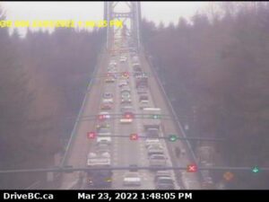
Cameras are located along key routes such as the Lions Gate Bridge, Burrard Bridge, and throughout high-traffic corridors in Vancouver. These spots are known for congestion, especially during peak hours, so being able to see conditions in real time helps you decide whether to take an alternate route or adjust your timing. You can also check for construction, accidents, or weather-related issues that might slow things down.
Visitors will find these traffic cams just as useful as locals. If you’re heading toward popular areas like Stanley Park or traveling along the waterfront, a quick look at current traffic can help you avoid unnecessary delays and keep your plans on track.
All camera feeds are updated regularly and are easy to access, making it simple to check multiple locations in just a few seconds. Whether you’re commuting, running errands, or exploring the city, Vancouver traffic cameras offer a practical way to stay informed and move through the city more efficiently.