Southern Interior British Columbia Traffic Webcams
Click Webcam to Enlarge
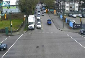
 YaleHwy 1, at Victoria Street in Yale, looking south. |
 Hells Gate – NHwy 1 at Bradley Hill, about 3.5 km south of Hells Gate, looking north. |
 Hells Gate – SHwy 1 at Bradley Hill, about 3.5 km south of Hells Gate, looking south. |
 Boston Bar – NHwy 1 at Kahmoose Rd, 12 km north of Boston Bar, looking north. |
 Boston Bar – SHwy 1 at Kahmoose Rd, 12 km north of Boston Bar, looking south. |
 Jackass Mnt. SummitHwy 1 at Jackass Mt. Summit, between Boston Bar and Lytton, looking north. |
 Cache CreekIntersection of Hwy 1 and Collins Rd, looking east on Hwy 1/97. |
 SavonaHwy 1 at Holloway Drive, near Savona, looking west. |
 KamloopsHwy 1 at Peterson Creek bridge in Kamloops, looking west. |
 Monte Creek – WHwy 1, between Monte Creek and Pritchard, looking west. |
 Monte Creek – EHwy 1, between Monte Creek and Pritchard, looking east. |
 SorrentoOn Hwy 1 at Highland Drive east of Sorrento, looking southeast. |
 Sicamous – WHwy 1, east of Sicamous at Cambie/Solsqua Roads, looking west. |
 Sicamous – EHwy 1, east of Sicamous at Cambie/Solsqua Roads, looking east. |
 Three Valley Gap20 km west of Revelstoke, looking east. |
 Clanwilliam Railway Overpass – WHwy 1, west of Revelstoke, looking west. |
 Clanwilliam Railway Overpass – EHwy 1, west of Revelstoke, looking east. |
 RevelstokeHwy 1 at east end of Columbia River Bridge in Revelstoke, looking east. |
 Albert CanyonHwy 1, about 30 km east of Revelstoke, looking east. |
 Jack McDonald SnowshedHwy 1, about 46 km east of Revelstoke, looking east. |
| Image Temporarily Unavailable.Rogers Pass
Hwy 1, near Parks Headquarters at Glacier National Park, 72 km east of Revelstoke, looking east. |
 Quartz CreekHwy 1, 40 km west of Golden, near the Quartz Creek bridge, looking east. |
 Donald Bridge – WHwy 1, about 28 km north of Golden at Donald Bridge, looking west. |
 Donald Bridge – EHwy 1, about 28 km north of Golden at Donald Bridge, looking east. |
 GoldenHwy 1, just north of Hwy 95 interchange, looking northwest. |
 Kicking Horse CanyonHwy 1 (Kicking Horse Canyon) at 10 Mile Brake Check, looking east. |
 Field-SWHwy 1 at Field Rd, about 16 km west of BC/Alberta border, looking southwest. |
 Field-NEHwy 1 at Field Rd, about 16 km west of BC/Alberta border, looking northeast |
") Lake Louise (West)Hwy 1 west of Lake Louise Overpass in Alberta, looking west. |
") Lake Louise (East)Hwy 1 west of Lake Louise Overpass in Alberta, looking east. |
") Banff (West)Hwy 1 east of Sunshine ski hill overpass in Alberta, looking west. |
") Banff (East)Hwy 1, east of Sunshine ski hill overpass in Alberta, looking east. |
 Hwy 3 at Hwy3/5 Jct-EHighway 3 at 3/5 junction looking east. |
 Hope SlideHwy 3 at the Hope Slide pullout, looking east. |
 Allison PassHwy 3 at Allison Pass, 10 km west of Manning Park resort area, looking east. |
 Sunday SummitOn Hwy 3, approximately 32 km south of Princeton. Looking north. |
 PrincetonHwy 3 at Frontage Rd on the west side of Princeton, looking south. |
 KeremeosHwy 3 at Keremeos Bypass Rd, looking west. |
 AnarchistHwy 3, 9 km west of the Anarchist Summit, east of Osoyoos, looking east. |
 Rock CreekHwy 3 at Hwy 33 junction in Rock Creek, looking north-west. |
 Eholt SummitHwy 3 at Eholt Summit, east of Greenwood, looking west bound. |
 Christina LakeHwy3 at East Lake Drive on east side of Christina Lake, looking northwest. |
 Paulson SummitHwy 3, about 3 km east of Paulson Summit, looking west. |
 CastlegarHwy 3 at 14th Ave. in Castlegar, looking east. |
| Image Temporarily Unavailable.Bombi Pass
Hwy 3, at the Bombi Summit, approximately 21.5 km south-east of Castlegar, looking west. |
 SalmoHwy 3 at Hwy 6, looking west on Hwy 3. |
 Kootenay PassHwy 3, Salmo Creston Highway Summit, looking east. |
 CrestonJunction of Hwy3 and Hwy3A at Creston, looking southeast. |
 YahkHwy 3 at Hwy 95, Yahk Weigh Scale, looking north-east. |
 CranbrookHwy3/95 at 9th Ave. in Cranbrook, looking northeast. |
 MorrisseyHwy 3, about 10km south of Fernie at Morrissey Jct, looking north. |
 HosmerHwy 3, in Hosmer, north of Fernie, looking north-east |
 SparwoodHwy 3 at Sparwood weigh scale, about 2 km west of the Alberta border, looking south-east. |
|||
 Balfour Ferry TerminalBalfour inland ferry terminal, looking north towards Hwy 3A. |
 Kootenay Bay Ferry TerminalKootenay Bay Ferry Terminal, looking northeast on Hwy3A. |
||
 Strawberry PassHwy 3B, about 15 km north of Rossland and 4 km south of summit, looking north. |
 RosslandHwy 3B at Hwy 22 (Rossland Weigh Scale) looking west on Hwy 22. |
 TrailHwy 3B at Devito Drive, looking east. |
|
 Clearwater – NHwy 5 at Clearwater Valley Rd, looking north. |
 Clearwater – SHwy 5 at Clearwater Valley Rd, looking south. |
 Little FortHwy 5, in Little Fort at Hwy 5/Hwy 24 junction, looking north. |
 BarriereHwy 5 at Agate Bay Rd, south of Barriere. Looking south. |
 WalloperHwy 5, 23 km South of Kamloops, looking north. |
 Helmer LakeHwy 5, 24 km north of Merritt at Helmer Interchange, looking north. |
 Larson HillHwy 5 at Larson HIll, 36 km south of Merritt, looking north. |
 Coquihalla LakesHwy 5, 61km south of Merritt, looking north. |
 Coquihalla Summit – NHwy 5, at Zopkios, near the Coquihalla Summit, looking north. |
 Coquihalla Summit – SHwy 5, at Zopkios, near the Coquihalla Summit, looking south. |
 Coquihalla Great Bear SnowshedGreat Bear Snowshed looking north. |
 Othello – NHwy 5 at Othello, about 11 km east of Hope, looking north. |
 Othello – SHwy 5 at Othello, about 11 km east of Hope, looking south. |
|||
| Image Temporarily Unavailable.Monashee Pass
Hwy 6, 83 km east of Vernon, looking westbound. |
 Fauquier FerryHwy 6 at Fauquier ferry landing, looking east. |
 Needles FerryHwy 6 at Needles ferry landing, looking west. |
 NakuspJunction of Hwy 6 and Hwy 23 in Nakusp, looking south along Hwy 6. |
 New DenverHwy 6 at Hwy 31A in New Denver, looking north. |
 NelsonHwy 6 near Hwy 3A and Rosemont/Uphill interchange, looking south. |
||
 HagensborgHwy 20, between Bella Coola and Hagensborg, looking west. |
 Heckman SummitHwy 20, about 88 km from Bella Coola, near gate at top of Bella Coola hill, looking west. |
 Anahim LakeHwy 20, near Anahim Lake, about 140 km east of Bella Coola, looking west. |
New! Mica DamHwy 23 at Mica Dam, about 152 km north of Revelstoke, looking south. |
 50-MileHwy 23, 90 km north of Revelstoke, looking north. |
 Shelter BayHwy 23 at Shelter Bay ferry landing, looking north. |
 Galena Bay – NHwy 23, about 48 km north of Nakusp, looking northbound. |
 Galena Bay – SHwy 23, about 48 km north of Nakusp, looking southbound. |
|||
 McDonald SummitHwy 24, 15 km west of Little Fort, looking west. |
 Sheridan LakeHwy 24, 63 km west of Little Fort, looking west. |
||
 Coffee CreekHwy 31, 45 km north of Nelson and 25km south of Kaslo, looking north. |
|||
 McCullochHwy 33, 41 km southeast of Kelowna, just south of Big White turnoff, looking north. |
|||
 Line Creek RoadHwy 43, between Sparwood and Elkford at Line Creek Mine Rd, looking north. |
|||
 Radium Hot SpringsHwy 93/95 junction, at Radium Hot Springs, looking east on Hwy 93 |
 Canal FlatsHwy 93 at Burns Avenue, looking south on Hwy 93. |
 WasaHwy 93/95 at junction of Hwy 95A, looking north. |
|
 BriscoHwy 95 in Brisco, at Brisco Road, looking north. |
|||
 KimberleyAbout 3 km south of Kimberley on Highway 95A at Black Bear Crescent, looking Southwest. |
|||
 HixonHwy 97 at Swanson Road near Hixon, looking north. |
 Dragon LakeHwy 97, 10.5 km south of Quesnel, looking south. |
 McLeese LakeHwy 97 and Beaver Lake Rd junction north of McLeese Lake, looking east. |
 Enterprise – NHwy 97, 37 km south of Williams Lake, looking north. |
 Enterprise – SHwy 97, 37 km south of Williams Lake, looking south. |
 Begbie SummitHwy 97, Begbie Summit, 100 Mile House area, looking north. |
 Big BarHwy 97, 8 km north of Clinton just before Big Bar rest area, looking north. |
 FalklandHwy 97 at Silvernails Road near Falkland, looking southeast. |
 Kalamalka LookoutHwy 97 at Vista Road turnoff south of Vernon, looking north. |
New! Winfield – NHwy 97, north of Winfield, by Wood Lake, looking north. |
New! Winfield – SHwy 97, north of Winfield, by Wood Lake, looking south. |
 KelownaHwy 97 at Hwy 33 in Kelowna, looking North on Hwy 97. |
 WR Bennett Bridge 02West end of WR Bennett Bridge connecting Kelowna and West Kelowna, looking west. |
 WR Bennett Bridge 04Mid span of WR Bennett Bridge connecting Kelowna and West Kelowna, looking west. |
 WR Bennett Bridge 07East end of WR Bennett Bridge connecting Kelowna and West Kelowna, looking west. |
 WR Bennett Bridge 11East approach to WR Bennett Bridge at Abbott Street, looking west along Hwy 97. |
 Callan RdHwy 97 at Callan Rd, about 6 km north of Summerland, about 15 km south of Peachland. Looking south. |
|||
 SpallumcheenHwy 97A at Larkin Cross Rd,about 14km north of Vernon, looking north. |
|||
 Highland Valley RdHwy 97C, at Highland Valley Rd, about 61 km north of Merritt and 46 km south of Ashcroft, looking north. |
 ElkhartHwy 97C (Okanagan Connector) 25 km east of Hwy 5A/97C Jct, looking west. |
 Pennask SummitHwy 97C, 74km west of Kelowna, looking east. |
Image Unavailable.Brenda Mine
Hwy 97C (Okanagan Connector) about 22km west of 97/97C Jct, looking east. |
 Lillooet-Fountain ValleyHwy 99, near Fountain Slide, about 15km north of Lillooet, l |